|
|
|
GIS-BASED WATERSHED ASSESSMENT
|
|
||
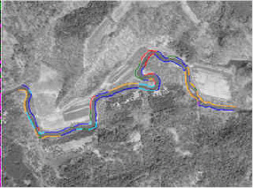
Mapping
of channel features in a GIS (Geographic Information Systems) format
enables watershed managers to anticipate how actions in one area may
impact fish habitat, water quality, or human developments elsewhere. We
can create GIS-based watershed maps with the information needed for making
difficult management decisions. These maps help in determining the
location and length of certain features such as eroding stream banks or
reaches without riparian buffers.
|
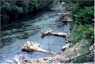
Field Geology Services designs stream restoration and bank stabilization
projects. We ensure that the best techniques are selected for each project
after a careful assessment of the problem. Our goal is to restore natural
stream function using techniques that protect human infrastructure while
improving salmon and trout habitat.
|
HOME Flood Hazard Studies Project Monitoring Short Courses Other Needs
|
(207) 491-9541 jfield@field-geology.com |
Copyright © 2002 - 2010 Field Geology Services and route2.com . All rights reserved.